Where Is Vesuvius? Map, Height and the Towns Around It
Mount Vesuvius is in southern Italy, on the eastern shore of the Bay of Naples, in the province of Naples in Campania. It stands less than 12 km south-east of the city of Naples and about 10 km from Pompeii, at roughly 40.821°N, 14.426°E. Its summit is 1,277 m above sea level by the national park’s figure (some sources, including the Smithsonian’s Global Volcanism Program, give 1,281 m). The towns of Ercolano, Torre del Greco and a dozen others climb its lower slopes, and the visitor path to the crater starts above Ercolano, on the side facing the sea.
This guide explains where the volcano sits on the map, how high and how big it is, how Monte Somma fits in, and where the places visitors actually go are in relation to it.
The short answer
- Country and region: Italy, Campania, province of Naples.
- Position: on the Bay of Naples, between Naples to the north-west and Pompeii and the Sorrento peninsula to the south-east.
- Distance from Naples: less than 12 km south-east of the city.
- Distance from Pompeii: about 10 km.
- Height: 1,277 m (park figure) or 1,281 m (Smithsonian and other park material).
- Crater: about 450 m across and 300 m deep.
- Where visitors go: the square at 1,000 m above Ercolano, where the crater path, trail 5 of the national park, begins.
Vesuvius on the map
Picture the Bay of Naples as a wide bowl open to the south-west. Naples sits on its northern shore. The coast then runs south-east through Portici, Ercolano and Torre del Greco towards Torre Annunziata and Pompeii, and finally turns west along the Sorrento peninsula, with Capri off its tip. Vesuvius rises behind that eastern shore, its cone visible from almost everywhere around the bay.
That position explains most of the practical geography:
- From Naples, the volcano is the skyline across the water to the south-east. The Circumvesuviana railway runs round its foot along the coast.
- From Ercolano (ancient Herculaneum) and Torre del Greco, you are on its western and south-western slopes, closest to the crater path.
- From Pompeii, you see it to the north-west, about 10 km away. Bus 808 runs from Pompeii up to the crater path.
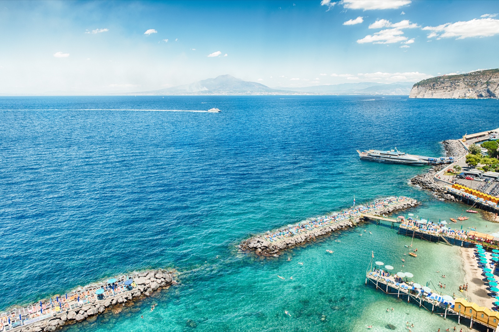
- From Sorrento, it is across the bay to the north, which is the view in the photo at the top of this page.
How high is Vesuvius?
The short answer is between 1,277 m and 1,281 m: sources differ by a few metres.
- 1,277 m is the height the national park gives on its geology page for the highest point of the cone.
- 1,281 m is the figure of the Smithsonian’s Global Volcanism Program, and it also appears on the park’s biodiversity page and its 2023 tourist map.
The difference reflects different surveys and the irregular crater rim rather than any change in the mountain. Either way, you do not climb to the true summit: the crater path runs along the lower edge of the crater and reaches a high point of about 1,170 m.
What you do see is the crater itself, about 450 m across and 300 m deep, with small fumaroles on the cone, a sign of what the park calls its state of “active rest”.
Two volcanoes in one: Somma-Vesuvius
Look at Vesuvius from Naples and you see two peaks, not one. The cone on the right is Vesuvius proper, the Gran Cono. The ridge on the left is Monte Somma, the remains of an older, larger volcano.
The Smithsonian describes the whole as a central composite volcano: an older stratovolcano, Monte Somma, with a summit caldera partly filled by the younger cone of Vesuvius. The park’s own description adds the detail:
- Monte Somma reaches 1,132 m at Punta Nasone and is about 15 km across at its base.
- It forms an arc, open to the south, that wraps around the northern side of the cone.
- Its jagged crest is a series of large rock spurs known locally as cognoli.
- Between the two lies the Valle del Gigante, divided into the Valle dell’Inferno to the east and the Atrio del Cavallo to the west, covered by the lava flows of recent centuries.
The cone in its present form probably began to grow after the AD 79 eruption, which demolished much of the old edifice. So when you stand on the crater path above Ercolano, the Somma ridge is the wall across the valley in front of you. For the eruptions themselves, see the AD 79 eruption article.
How big is Vesuvius?
By area, the most useful figure is the national park’s: 8,482 hectares across 13 municipalities, which takes in the cone, Monte Somma and the wooded upper slopes. The towns of the coast and the plain lie mostly outside the park but very close to it.
Vesuvius belongs to a wide volcanic area that formed about 2 million years ago, and its present form is the result of explosive and effusive eruptions over the last 25,000 years. It has been active for about 40,000 years, and it is the only active volcano of continental Europe. It has been quiet since its last eruption in 1944. For what that means today, see is Vesuvius still active?.
The towns on its slopes
The national park lies in the province of Naples and covers parts of 13 municipalities, all on the mountain itself:
| Side of the volcano | Park municipalities |
|---|---|
| West, facing Naples and the sea | Ercolano, Torre del Greco |
| South, towards Pompeii | Trecase, Boscotrecase, Boscoreale |
| East | Terzigno, San Giuseppe Vesuviano, Ottaviano |
| North, behind Monte Somma | Somma Vesuviana, Sant’Anastasia, Pollena Trocchia, Massa di Somma, San Sebastiano al Vesuvio |
The sides in the table are approximate, but they help to read a map. They also tell you where the trails start: Ottaviano for the Valle dell’Inferno, Somma Vesuviana for Monte Somma, Trecase for the Strada Matrone, Ercolano for the crater. See the hiking trails guide.
Around those towns lives a very large population. About 700,000 people live at the foot of the volcano, which is why it is considered one of the highest-risk volcanoes in the world. The civil protection red zone includes 25 municipalities in the provinces of Naples and Salerno, and the yellow zone 63 municipalities and three districts of Naples.
Where the crater path starts
For visitors, the key point on the map is not the summit but the square at Quota 1000, at the end of the Ercolano-Vesuvio provincial road. That is where trail 5, the Gran Cono, begins.
- No parking on the square. Drivers use the Comune di Ercolano’s car parks lower down the road, at Quota 800 and Quota 1000, and walk or take the shuttle up.
- The crater path runs about 3,807 m in total, climbing about 140 m to its high point of 1,170 m.
- From Pompeii, EAV bus 808 runs to the Vesuvio Quota 1000 stop, right at the start of the path, in about 55-70 minutes.
- From Ercolano Scavi station, the private Vesuvio Express shuttle takes visitors to the entrance at 1,000 metres.
The other way up is on foot from Trecase, on the south side, along the old Strada Matrone to the square at Quota 1050. Everything about transport is in getting to Vesuvius.
Distances from the places you are staying
The volcano sits in the middle of the area most visitors use as a base:
- Naples: less than 12 km to the volcano as the crow flies, but the trip to the crater path is two legs: the Circumvesuviana to Ercolano Scavi or Pompei, then a shuttle or bus up.
- Ercolano (Herculaneum): on the lower slopes. From Ercolano Scavi station it is 6 minutes on foot to the archaeological park, and the Vesuvio Express leaves from the station square.
- Pompeii: about 10 km. Bus 808 goes from Pompeii to the start of the crater path.
- Sorrento: across the bay; from Sorrento you take the Circumvesuviana to Pompei Villa dei Misteri and then bus 808, or join a tour with pickup.
Because the volcano is so central, a half-day visit fits easily around the ruins. See Vesuvius and Pompeii in one day.
Pompeii, Herculaneum and the volcano
A common question is whether Pompeii is “at the foot” of Vesuvius. Roughly, yes: Pompeii is about 10 km from the volcano, on the plain to the south-east, and Herculaneum is closer still, on the western slope by the sea. The AD 79 eruption reached both, in different ways; pyroclastic currents travelled up to 15 km from the crater.
On a map the three form a rough triangle:
- Vesuvius in the middle, with the crater path on its western side.
- Herculaneum at Ercolano, on the coast below the crater path.
- Pompeii to the south-east, beyond Torre Annunziata.
That is why the combined tours run Naples, Vesuvius and Pompeii, or Pompeii, Herculaneum and Vesuvius, in a single day.
Getting your bearings on the crater path
Once you are on the path, the map makes more sense if you know what you are looking at. The park describes the Gran Cono trail as running along the lower edge of the crater, with views of Monte Somma, the Valle del Gigante and the Bay of Naples and its islands.
- Behind you and to the north, across the Valle del Gigante, rises the long wall of Monte Somma, with Punta Nasone at 1,132 m as its highest point. From the square at Quota 1000 you already see its northern side and the Cognoli di Sant’Anastasia.
- Below you to the west, the coast runs from Naples through Portici and Ercolano to Torre del Greco, with the bay beyond.
- Further out, on clear days, the islands of the bay and the Sorrento peninsula close the view to the south-west.
- Inside the rim, the crater drops away, about 300 m deep.
On hazy days the panorama shrinks to the crater and the nearest slopes, so check the Vesuvius weather page and pick a clear day if you can.
Vesuvius and the other volcanoes of Naples
Vesuvius is not the only volcanic area around Naples. On the other side of the city, to the west, lie the Campi Flegrei, a separate volcanic field, which has moved to the yellow alert level, while Vesuvius stays at green, meaning nothing anomalous compared with the ordinary activity of recent decades. The two are often confused by visitors, but they are distinct systems, watched round the clock by the Osservatorio Vesuviano, the Naples section of INGV.
For a visit, the difference is simple: the crater walk is on Vesuvius, south-east of Naples. Nothing about the Campi Flegrei alert changes access to the Gran Cono, which is governed by the national park’s own opening rules and weather closures.
The coast below: the Miglio d’Oro
Between Naples and Torre del Greco, along the coast at the foot of the volcano, runs the stretch the park calls the Miglio d’Oro, the “golden mile” of 18th-century villas built when this shore was a favourite retreat. It is part of the Somma-Vesuvio and Miglio d’Oro biosphere reserve included in the national park’s protected areas, and it is the landscape you cross on the Circumvesuviana between Naples and Ercolano. The park also lists the Pietrarsa railway museum in Portici and the coral museum in Torre del Greco along this shore.
Seeing Vesuvius from around the bay
You do not need to climb it to see it. Some of the best views are from a distance:
- From the Naples waterfront and the hill of Posillipo, the double profile of Somma and the cone fills the skyline across the bay, especially clear in winter when there is snow on the summit.
- From the Sorrento coast, it rises across the water to the north, above the towns along the far shore.
- From Pompeii, it stands over the ruins to the north-west, the view that makes the story of AD 79 so vivid.
From the crater path itself, the view goes the other way: over the bay to Naples and the islands, and across the Valle del Gigante to the cliffs of Monte Somma.
What kind of volcano is Vesuvius?
In simple terms, a stratovolcano: a steep cone built of layers of lava and ash. More precisely, Somma-Vesuvius is a composite volcano with a caldera, as described above. Since the sub-Plinian eruption of 1631, Vesuvius has erupted in Strombolian and mixed effusive-explosive styles, mostly inside the Somma caldera, until the last eruption in 1944. Its most famous eruption, in AD 79, was Plinian, a particularly violent type named after Pliny.
Reading a map of the national park
If you pick up the park’s tourist map, three landmarks help you orient yourself:
- The Gran Cono, at the centre, with the crater path on its western flank above Ercolano.
- The arc of Monte Somma, to the north, with Punta Nasone as its highest point.
- The Tirone-Alto Vesuvio forest reserve, on the western slopes between the coast and the cone.
The trails are numbered 1 to 11 and start from different towns around the mountain. The park authority itself is based at Palazzo Mediceo in Ottaviano, on the eastern side. For what the park protects and how to visit it, see the national park guide.
Frequently asked questions
Where is Mount Vesuvius?
In Campania, southern Italy, on the eastern shore of the Bay of Naples, less than 12 km south-east of Naples and about 10 km from Pompeii.
How high is Vesuvius?
The national park gives 1,277 m and the Smithsonian 1,281 m. The crater path tops out at about 1,170 m.
Is Vesuvius near Naples?
Yes. It is less than 12 km south-east of the city and visible across the bay from the waterfront.
How far is Vesuvius from Pompeii?
About 10 km. Bus 808 runs from Pompeii to the start of the crater path in about 55-70 minutes.
Where do you start the climb up Vesuvius?
From the square at Quota 1000, at the end of the Ercolano-Vesuvio road above Ercolano. You need a timed online ticket; see the crater ticket guide.
Which side of Vesuvius do you climb?
The western side, facing the sea. The crater path starts above Ercolano and runs along the lower edge of the crater, with the bay below you. The alternative walking route, the Strada Matrone, comes up the southern side from Trecase.
Is Vesuvius in a national park?
Yes. Vesuvius National Park was established on 5 June 1995 and covers 8,482 hectares across 13 municipalities, including the cone, Monte Somma and the Tirone-Alto Vesuvio forest reserve. The crater path is trail 5 of the park’s network of 11 trails.
Can you see Vesuvius from Sorrento?
Yes. It rises across the bay to the north, above the towns of the far shore, and on clear days the double outline of Monte Somma and the cone is easy to pick out.