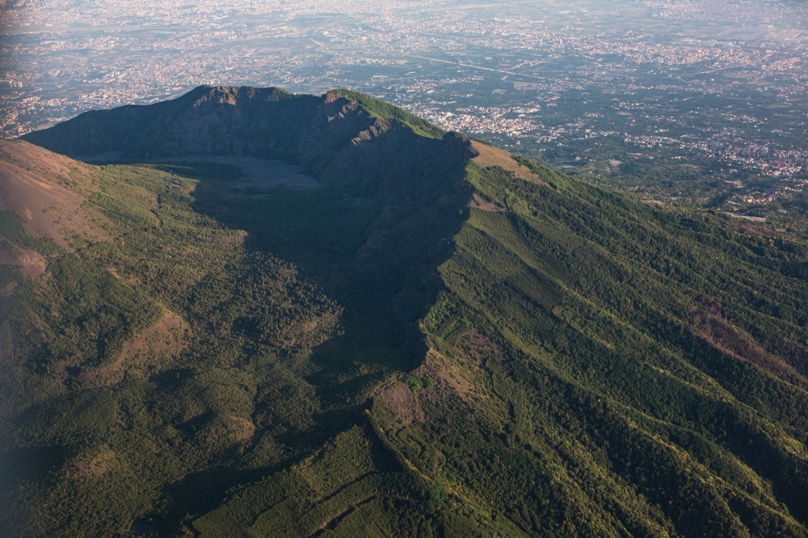
Vesuvius Hiking Trails: The Park's 11 Paths Beyond the Crater
Most visitors only ever walk one path on Vesuvius: the crater path, trail no. 5, from the square at 1,000 m above Ercolano. But the national park has 11 trails with 54 km of walkway in all, and the best of them are proper hikes: down into the Valle dell’Inferno between the cone and the old Monte Somma, along the jagged Cognoli ridges, up to Punta Nasone at 1,132 m, through the pine woods of the Tirone reserve, or all the way up to the crater on foot along the old Strada Matrone from Trecase. This guide covers each trail with the park’s own figures for length, height, time and difficulty, which ones are open, and how to choose.
The short answer
- For the crater itself, walk trail 5, the Gran Cono, with a timed online ticket. See the crater ticket guide.
- To walk up to the crater rather than drive, trail 6, the Strada Matrone, climbs from Trecase and is free; you still need a crater ticket for the rim.
- For a full hiking day, trail 1 (Valle dell’Inferno) or trail 2 (Lungo i Cognoli) from Ottaviano: 7 to 8 hours, graded high.
- For something short and easy, trail 9 (the 1944 lava flow, about 1 hour) or trail 11 (a level boardwalk in a pine wood, 30 minutes).
- At weekends only, trail 4 through the Tirone reserve, with park guides on the trail.
How the trail network works
The park built its trail network in 2001-2003: 11 trails, waymarked, with information boards on the plants, rocks and history along the way. They are not all the same kind of walk. The park describes six circular nature trails (nos. 1, 2, 3, 4, 5 and 8), an educational trail (no. 9), a panoramic trail (no. 6) and an agricultural trail (no. 7), plus the level pine-wood walk at Terzigno (no. 11) and the farm lane of L’Olivella (no. 10).
Three things are worth knowing before you set off:
- The network is being redeveloped. The park says some trails may have no signs or waymarks, and asks walkers to contact it for up-to-date information. Do not rely on finding a signpost at every junction.
- Some trails or sections are closed. At the time of writing the park lists trail 2 as unusable on the section towards Somma Vesuviana, trail 3 on the section from Somma Vesuviana, and trails 8 and 10 as not usable while maintenance is planned. The link from trail 1 to trail 6 is also closed because of works.
- You are responsible for yourself. The park authority says it has no remit for safety and is not responsible for harm to people or property, and it asks walkers to take great care, always check the weather and wear suitable shoes.
The park’s 2023 tourist map gives slightly different headline figures (11 paths and 70 km of walkway, with a maximum altitude of 1,281 m), so treat totals as approximate; the figures below come from each trail’s own page.
The trails at a glance
| Trail | Start | Length (return) | Highest point | Time (return) | Difficulty |
|---|---|---|---|---|---|
| 1 Valle dell’Inferno | Ottaviano | 12,390 m | 1,000 m | 7 hours | High (long) |
| 2 Lungo i Cognoli | Ottaviano | 8,134 m | 1,112 m | 8 hours | High |
| 3 Il Monte Somma | Somma Vesuviana | 7,650 m | 1,132 m | 5 hours | High |
| 4 Riserva Tirone | Ercolano-Vesuvio road | 11,260 m | 625 m | 6 hours | Medium |
| 5 Il Gran Cono | Quota 1000, Ercolano | 3,807 m | 1,170 m | about 3 hours | Medium |
| 6 Strada Matrone | Via Cifelli, Trecase | 14,175 m | 1,060 m | 7 hours | Medium |
| 7 Vallone della Profica | San Giuseppe Vesuviano | 4,382 m | 730 m | 3 hours | Medium |
| 8 Trenino a Cremagliera | San Sebastiano al Vesuvio | 2,906 m | 538 m | 2 hours | Medium |
| 9 Il Fiume di Lava | Osservatorio, Ercolano | 1,039 m | 568 m | 1 hour | Low |
| 11 Pineta di Terzigno | Via Vecchia Campitelli | 1,500 m | 211 m | 30 minutes | Low |
Trail 10, L’Olivella, follows a country lane through the farmland of Sant’Anastasia, but it is listed as not usable and the park gives no data sheet for it at present.
Trail 5: the Gran Cono
This is the crater path, and the only trail with a ticket. It starts from the square at 1,000 m in Ercolano, at the end of the Ercolano-Vesuvio provincial road, and is about 3,807 m in total, topping out at 1,170 m with roughly 140 m of climbing at an average 14% gradient. Entry is in groups of 60 every 10 minutes, with tickets sold only online up to 30 days ahead.
A few practical points that matter to hikers in particular:
- There is no parking on the square and there are temporarily no public toilets there. Drivers park lower down at the Comune di Ercolano’s car parks.
- The visit must end within one hour of the last permitted entry. In winter the last entry is 15:00; in July and August it is 18:00.
- Wind, rain or snow can close the path. Refunds are given only if the path is closed for bad weather or force majeure.
Everything about booking is in the crater ticket guide, and the ways of reaching the square are in getting to Vesuvius.
Trail 6: the Strada Matrone, walking up to the crater
If you would rather earn the view, this is the trail. It follows the old road built by the Matrone brothers up the Trecase side of the volcano, opened as a carriage road on 4 January 1927 after almost thirty years of work, repeated destruction by lava and rebuilding.
- Length: 14,175 m return; the park also describes it as about 8 km long one way.
- Highest point: 1,060 m, at the square at Quota 1050, from where you walk on to the Gran Cono.
- Time: about 7 hours return.
- Difficulty: medium, a long slope, partly asphalted.
- Start: Via Cifelli in Trecase.
The trail was badly damaged by the fire of 2017 and has been restored by the park. It is now open again as a walking and cycling route, keeps the same opening hours as the Gran Cono, and access to the trail is free. The crater rim itself is still entered by timed ticket, so book a crater slot for the time you expect to arrive at the top and use the 120-minute window either side.
Because it shares the crater’s hours, start early: in November to February the last entry to the crater is 15:00, which leaves little margin for a long walk up.
Trail 1: the Valle dell’Inferno
The park calls this one of the most beautiful and representative routes in the protected area, and it is the classic Vesuvius hike. The access barrier is 4 km from the centre of Ottaviano, on the road that climbs towards Monte Somma, past the Palazzo Mediceo, which the Medici owned from 1567 and which now houses the park authority’s headquarters.
- Length: 12,390 m return.
- Highest point: 1,000 m.
- Time: 7 hours return.
- Difficulty: high, because it is long.
The route starts with asphalt hairpins, then becomes a dirt path through stone pines and then mixed woodland of chestnut, Neapolitan alder and maple, holm oak and robinia, full of woodpeckers. At Largo Angelo Prisco, named after a finance police officer killed by poachers in 1995, trails 1 and 2 separate.
Beyond a broom-covered clearing with a sudden view of the volcano, where you see the 1937 lava dome and vents formed around the turn of the 19th and 20th centuries, the path drops into the Valle dell’Inferno itself: scrub below walls and spires of lava, the home of ravens, peregrine falcons and rock thrushes. On the way back along the Cognoli di Levante you can see, and step into, tunnels shaped by recent “ropy” lava.
The Valle dell’Inferno is the eastern half of the Valle del Gigante, the valley between the cone and Monte Somma; the western half is the Atrio del Cavallo. In places Etna broom, introduced after the 1906 eruption, forms impenetrable thickets here, so stay on the path.
Trail 2: Lungo i Cognoli
The park’s description is “the most striking and wildest scenery of Somma-Vesuvius”, and it is the tougher of the two Ottaviano routes.
- Length: 8,134 m return.
- Highest point: 1,112 m, the Cognoli di Ottaviano.
- Time: 8 hours return.
- Difficulty: high.
It shares its first stretch with trail 1, climbing steeply for over 1 km to Largo Angelo Prisco, then continues through chestnut and pine to open broom scrub with Bourbon-era dry-stone walls. From the panoramic square you look over Punta Nasone, the Gran Cono, the Atrio del Cavallo filled by the 1944 lava and the Valle dell’Inferno.
Then the real ridge walk begins: a steep climb to the Cognoli di Ottaviano (1,112 m), a series of ups and downs over volcanic sand to a saddle at 1,001 m, and a very steep descent into the Valle dell’Inferno. On the Cognoli di Levante you pass what the park calls the finest formation of ropy lava on Vesuvius, cut by a deep fissure full of ferns, before reaching a clearing at 780 m and returning by a dirt road. Remember the section towards Somma Vesuviana is currently unusable.
Trail 3: Monte Somma and Punta Nasone
This loop climbs to Punta Nasone, at 1,132 m the highest summit of Monte Somma, the older volcano whose arc wraps around the north side of the cone.
- Length: 7,650 m return.
- Highest point: 1,132 m.
- Time: 5 hours return.
- Difficulty: high.
- Start: the church of Santa Maria delle Grazie a Castello, Somma Vesuviana.
The first 800 m or so, along the old Via Traversa, are fitted out for blind visitors and people with reduced mobility, with a rope handrail and raised markers every 100 metres. After that the path becomes steep, over the Cognoli di Trocchia (961 m) and di Sant’Anastasia (1,086 m), with the Bay of Naples and the Campanian plain on one side and the Tirone reserve and the cone on the other. In spring the orange lily flowers here.
The summit overhangs the Valle del Gigante, with small refreshment huts, a chapel to the Madonna and a large cross. The return passes the Cognoli di Giacca (703 m). Because the park currently lists the section from Somma Vesuviana as unusable, contact the park before planning this one.
Trail 4: through the Tirone reserve
The easiest long walk on the mountain: wide, mostly level, inside the Tirone-Alto Vesuvio forest reserve, which covers about 1,000 hectares.
- Length: 11,260 m return.
- Highest point: 625 m.
- Time: 6 hours return.
- Difficulty: medium (long and sloping).
- Start: the Ercolano-Vesuvio provincial road.
It is open two days a week, Saturday and Sunday, from 9:00 to 16:00 (last entry 15:00), with park guides on the trail. Entry from the Via Vesuvio gate is free and no booking is currently needed.
Expect stone pine planted to hold the unstable slopes, wild orchids in spring, and a long stretch alternating shade and open views of the Bay of Naples and the Gran Cono, with a viewpoint over a branch of the 1944 lava flow. The reserve’s reptiles include the rare but harmless Aesculapian snake.
Short and easy walks: trails 9 and 11
Not every walk here has to be a day out.
Trail 9, Il Fiume di Lava, is the park’s educational trail and the best short walk on Vesuvius: 1,039 m return, 1 hour, graded low, starting from Via Contrada Osservatorio in Ercolano. It passes a narrow cutting where pumice from the AD 79 eruption shows in the walls, then Mediterranean scrub, and ends on the “river of lava” itself: the flow of the 1944 eruption, which emitted 21 million cubic metres of lava, now silvery grey with the pioneer lichen Stereocaulon vesuvianum. It starts near the Osservatorio Vesuviano, so you can pair it with the observatory museum (see the national park guide).
Trail 11, La Pineta di Terzigno, is a 1,500 m level loop in a pine wood, 30 minutes, graded low, built by the park in 2004-2005 for easy walks and for people with reduced mobility. It is a wide wooden boardwalk with a rope handrail, panels with texts in braille and a “garden of scents” of Mediterranean scrub plants.
Trail 8, Il Trenino a Cremagliera, follows part of the old rack railway from San Sebastiano (2,906 m return, 2 hours), including a fumarole where you can feel the volcano’s heat at only 450 m, but it is currently listed as not usable.
Trail 7: the Vallone della Profica
The park’s agricultural trail climbs the less-known eastern slopes of Monte Somma from Santa Maria alla Scala in San Giuseppe Vesuviano (175 m) to 730 m: 4,382 m return, 3 hours, graded medium, with free access on foot. It begins among fig, apricot, cherry and plum trees, vineyards and hazel groves, then climbs through oak, pine and chestnut to the Somma crests, where it meets trails 1 and 2.
Which trail for which walker
- First visit, limited time: trail 5 only. It is the view everyone comes for.
- Fit walkers who want the crater on foot: trail 6 from Trecase, with a crater ticket timed for your arrival.
- Experienced hikers with a full day: trail 1, or trail 2 for steeper, wilder ground.
- Summit collectors: trail 3 to Punta Nasone, once the park confirms it is open.
- A gentle weekend walk with a guide around: trail 4.
- Children, older walkers or limited mobility: trails 9 and 11. See Vesuvius with kids.
Safety, rules and what to bring
The park’s rules, printed on its map, are short: no fires, no litter, no disturbing animals, no collecting minerals or plants, no leaving the marked paths, no camping and no motor vehicles. Bivouacking is banned too.
For the long trails, bring:
- Proper walking shoes. Volcanic sand and loose lapilli are hard work and slippery on the descents.
- Plenty of water and food. Facilities are scarce; even the Gran Cono square has no public toilets at present.
- Layers and a windproof. Above the woods there is little shelter, and wind is the most common reason the crater closes.
- A downloaded map. Signs may be missing, and the park’s pages offer a download of each route.
Check the Vesuvius weather page the day before, and remember the park asks you always to check conditions before you set out.
Getting to the trailheads
The trailheads are spread around the mountain, in different towns:
- Ottaviano: trails 1 and 2, on the road up from the Palazzo Mediceo.
- Somma Vesuviana: trail 3.
- Ercolano: trails 4 and 5 on the provincial road, and trail 9 by the Osservatorio.
- Trecase: trail 6.
- San Giuseppe Vesuviano, San Sebastiano and Terzigno: trails 7, 8 and 11.
Only the crater path is served by the visitor buses and shuttles described in getting to Vesuvius. For the others, a car or a taxi from the nearest Circumvesuviana station is usually the practical answer.
Combining a trail with the crater
The neatest combinations stay on the Ercolano side. Trail 9 starts near the Osservatorio, on the road up to Quota 1000, so a morning on the lava flow can lead to an afternoon slot on the crater. Trail 4, at weekends, also starts from the Ercolano-Vesuvio road. If you only want the crater and the bay views without organising transport, a crater ticket or a transfer from Pompeii or Naples covers the logistics.
Frequently asked questions
Can you hike up Vesuvius?
Yes. Trail 6, the Strada Matrone, climbs from Trecase to the square at Quota 1050, from where you walk on to the Gran Cono. The trail is free; the crater rim needs a timed ticket.
How long is the hike to the crater of Vesuvius?
From the Quota 1000 square the crater path is about 3,807 m in total and takes about 3 hours there and back. On foot from Trecase, trail 6 is 14,175 m return and takes about 7 hours.
What is the best hike on Vesuvius?
For most hikers, trail 1, the Valle dell’Inferno from Ottaviano: 12,390 m return, about 7 hours, through woods and lava between the cone and Monte Somma.
Are the Vesuvius trails open all year?
The crater path follows seasonal hours and can close in bad weather. Trail 4 opens only at weekends. Several trails or sections are currently closed for maintenance, so check with the park before you go.
Is there an easy walk on Vesuvius?
Yes: trail 9 to the 1944 lava flow (about 1 hour) and trail 11 in the Terzigno pine wood (30 minutes, level).